
 |
| Saxon King Edred/Eadred. |
When Calne was founded, by who, and why, are not known. It may well be that the Roman town of Verlucio (near Sandy Lane) was abandonned and left to return to the wilderness from which it had been carved. Residents may have then moved to create Calne, Chippenham, and Melksham.
However, It would seem that, due to present day topography, Calne may be a middle saxon town(2), a time period which extends from 660CE to 899CE. The layout of Calne at this early time is thought to be a church south of the river Marden, which seems to have included The Green in Saxon times(3) with a Royal palace complex to the south of the church (possibly what is now known as Kingsbury Street).
The early buildings in Calne will have likely been wattle and covered in a clay daub. There were many marshes around Calne that could supply the clay for daub. The names of some of these marshes are with us today, and while some are reasonably obvious: Calne Marsh, which was known as la Mershe de Calne in 1305, others such as Laggus Farm, Calne Without which is said to mean ‘long marshy meadow.’(4) are not. Over time, bridges and mills would have been required, but I am not currently aware of any old enough to include here.
 |
| St. Mary's, Calne. |
There is certainly a precedent for Kingsbury to refer to a Royal villa or complex in the form of Wilton, South Wiltshire. This town was once the Capital of Wessex and there are similarities in early layout, with the church being to the north and the Royal villa being to the south. In Wilton, a Royal burh, Kingsbury is known as the site of the Royal palace complex(7,8).
 |
| The Almshouses, Kingsbury Street, Calne. |
A book written by Wulfstand in 1000 details the life of Saint Swithun, who died in 862CE, within this tome he provides an account of a prisoner that was under the care of the magistrate of "the king's little village of Calne". So while we may consider Calne to be little more than a hamlet in the 800s, Calne did seem to have a permanent employee of the King in residence at his own abode. This person probably managed the administration of Calne Hundred during this time.
In 978 a Witan was assembled under Dunstan, the archbishop of Canterbury, at the king's house. This building is said to have been a rectangle hall around 5.5m by 24m and had bow-shaped sides. The Grove Encyclopedia of Medieval Art and Architecture(9) records that this building may have been a first-floor hall and that the bow-sided halls date back as far as the Neolithic period in the north of Germany. The encyclopedia goes on to say that these first floor halls may well have been ceremonial rather than domestic - a perfect location for a Wittan.
This Wittan, otherwise known as a "meeting of wise men" was an assembly for the ruling class and included those of the church and secular noblemen. This witan, held on the first floor of king's home in Calne, discussed the celebacy of the clergy and secular priests being replaced by Benedictine monks. Apparently, the floor suddenly gave way, injuring and killing some of the men who were against these ideas of reform. Dunstan was standing on a beam that survived this collapse and survived himself - which some see as devine intervention and God's will for celebacy and the return of the Benedictine monks.(10)
In the Domesday book of 1086, King Edward was recorded as the Lord of both towns in 1066, replaced by King William by 1086. The total population in 1066 was 114.5 households, which made this a very large population in comparison to other towns recorded.
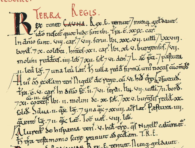 |
| Calne entry, Domesday book 1086. Source: http://opendomesday.org/place/ST9971/calne/ |
There doesn't seem to be any evidence of Norman building in Calne until they built an arch, a transept, and nave at St Mary's and added five-bay arcades in around 1160CE, which occurred at a church already standing on this location. For a people known to destroy whole streets to add a castle here or a church there, this seems quite delicate. So, perhaps, for the common people of Calne, life after 1066 was much the same as prior to the Norman invasion?
As we can see, Calne has been a valued place ever since historical records began. From a small hamlet owned by the king, it was built up into what was considered a large settlement by the time of the Domesday book. Over the next centuries, Calne would grow and prosper, but most importantly, it would persevere and become stronger in the face of diversity times of major ecomomic strife.
References:
1: Calne, Past and Present: August 2017. 2018. Calne, Past and Present: August 2017. [ONLINE] Available at: https://calnepastandpresent.blogspot.com/2017/08/. [Accessed 26 June 2018].
2: Haslam, J., 2010. Early Medieval Towns in Britain C700 to 1140. Shire.
3: History Borough Town Calne by A E W Marsh
4: Place Names of Wiltshire, Gover et al, 1939
5: Anna Powell-Smith. 2018. Calne | Domesday Book. [ONLINE] Available at: http://opendomesday.org/place/ST9971/Calne/. [Accessed 26 June 2018].
6: Place Names of Wiltshire, Gover et al, 1939
7: The borough of Wilton: Introduction | British History Online. 2018. The borough of Wilton: Introduction | British History Online. [ONLINE] Available at: http://www.british-history.ac.uk/vch/wilts/vol6/pp1-7. [Accessed 26 June 2018].
8: History of Wilton | Wilton Town. 2018. History of Wilton | Wilton Town. [ONLINE] Available at: http://wiltontown.com/history-of-wilton/. [Accessed 26 June 2018].
9: Hourihane, H., 2012. The Grove Encyclopedia of Medieval Art and Architecture. Oxford Univ Pr.
10: Turner, S., 2018. The History of the Anglo-Saxons (Cambridge Library Collection - Medieval History) (Volume 2). Cambridge University Press.
11: Anna Powell-Smith. 2018. Calne | Domesday Book. [ONLINE] Available at: http://opendomesday.org/place/ST9971/calne/. [Accessed 26 June 2018].

